Faculty of Science, Technology and Medicine
 Faculty of Law, Economics and Finance
 Faculty of Humanities, Education and Social Sciences
 Interdisciplinary Centre for Security, Reliability and Trust
 Luxembourg Centre for Systems Biomedicine
 Luxembourg Centre for Contemporary and Digital History
 Luxembourg Centre for European Law
 Luxembourg Centre for Socio-Environmental Systems
Coordinate determination and monitoring of the GNSS reference stations within the satellite positioning service Luxembourg (SPSLUX-LUREF)
The project at a glance
-
Start date:01 Nov 2013
-
Duration in months:72
-
Funding:Administration du cadastre et de la topographie (ACT)
-
Principal Investigator(s):Félicia Norma Rebecca TEFERLE
About
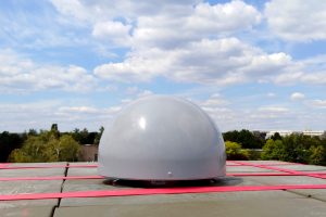
In this ongoing series of consultancy projects to the Administration du cadastre et de la topographie (ACT) since 2013 the University of Luxembourg’s team Geodesy and Geospatial Engineering re-computed the coordinates for the GNSS reference stations of the Satellite Positioning Service Luxembourg (SPSLux) in 2014, 2019 and 2020. These stations form the first order stations of the Luxembourg coordinate reference frame (LUREF), which is fundamental to all mapping, navigation and surveying related activities within the Grand-Duchy. Due to ongoing deformations of the Earth, both natural and anthropogenic, on time scales from days to decades, regular re-computations of the national reference coordinates in a global reference coordinate frame are necessary to maintain millimeter level accuracy on a national level. Such high accuracies are required so that, e.g., building and infrastructure can be developed and constructed safely, communes can manage their services and framers can employ precision farming. With the availability of smart devices coordinate reference frames are used by everyone, everywhere and at all times without the user being aware of it. Over the aforementioned period since 2013 updates to the LUREF reference station coordinates were necessary due to the evolving global (ITRF2008, ITRF2014 and ITRF2020) and European (ETRF2008, ETRF2014 and ETRF2020) reference coordinate frames, the evolving GNSS (modernizations of the U.S. GPS and Russian GLONASS) as well as the addition of the new GNSS (Chinese BDS and the European Galileo) constellations, the replacement of GNSS equipment or the change in the location of the GNSS stations in Luxembourg. Currently the team is contributing to SPSLUX with a GNSS reference station on Campus Kirchberg and is developing the tools that will allow to permanently monitor the coordinates of the SPSLUX reference stations within the frames of the European Terrestrial Reference System (ETRS), i.e., EUREF, the International Terrestrial Reference Systems (ITRS), i.e., the ITRF, and LUREF itself.
Organisation and Partners
Administration du cadastre et de la topographie
Project team