Faculty of Science, Technology and Medicine
 Faculty of Law, Economics and Finance
 Faculty of Humanities, Education and Social Sciences
 Interdisciplinary Centre for Security, Reliability and Trust
 Luxembourg Centre for Systems Biomedicine
 Luxembourg Centre for Contemporary and Digital History
 Luxembourg Centre for European Law
 Luxembourg Centre for Socio-Environmental Systems
The King Edward point geodetic observatory, South Georgia Island, South Atlantic Ocean (KEPGO)
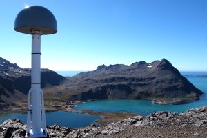
The King Edward Point Geodetic Observatory (KEPGO), South Georgia Island, South Atlantic Ocean
The project at a glance
-
Start date:01 Feb 2013
-
Duration in months:72
-
Funding:University of Luxembourg Internal Research Grant
-
Principal Investigator(s):Félicia Norma Rebecca TEFERLE
About
During February 2013 the King Edward Point (KEP) Geodetic Observatory (KEPGO) was established at KEP Research Station in Cumberland Bay East on the northern coastline of South Georgia Island (170 x 50 km at 5417’S, 3629’W) by team Geodesy and Geospatial Engineering (GGE) through the University of Luxembourg funded research project “New Geodetic Infrastructure and Reprocessed GPS Solutions for Sea Level, Climate Change and Geodynamics (GSCG)”. The activities were carried out in collaboration with the United Kingdom’s National Oceanography Centre (NOC) and the British Antarctic Survey (BAS), with permission granted by the Government of South Georgia and the South Sandwich Islands. With its mid-ocean location in the Southern Atlantic Ocean, South Georgia Island is in a key position for the oceanic (Global Sea Level Observing System (GLOSS)), and geodetic (International GNSS Service (IGS) and International Terrestrial Reference Frame (ITRF)) global monitoring networks that are fundamental to climate change research. These networks lack sampling density in this vast region between the South Atlantic and Southern Oceans, which is a key region for the formation of global weather. Moreover, these networks also suffer from a Hemisphere imbalance with the number of stations/tide gauges in the Northern Hemisphere outnumbering those in the Southern Hemisphere. Hence operating the KEPGO to the highest standards is of key scientific value. Besides improving the geodynamic/tectonic understanding of this region, for the teams GGE and NOC the particular interest is to monitor the vertical land movements and datum of the tide gauge to establish a continuous record within the Permanent Service for Mean Sea Level (PSMSL). This makes the tide gauge useful for long-term sea level studies and satellite altimetry calibrations. The KEPGO consists of two permanent Global Navigation Satellite System (GNSS) stations, with international IDs KEPA#42701M001 and KRSA#42702M001, the tide gauge (GLOSS ID 187), in operation on and off since 1957 with recent instrument updates in 2008 and 2020, and local networks of geodetic benchmarks that allow the geo-referencing of the tide gauge to the GNSS stations and thus to the ITRF. Results presented by the team from the GNSS, precise levelling, tide gauge and satellite altimetry measurements showed that while South Georgia Island and the area around KEP are rising, the jetty and tide gauge are subsiding relative to the rest of the island, and while the sea level records from both sources agree well in their features, they show a significant difference in the sea level rates. The data also suggest that South Georgia Island and its shelf area form a micro-continent that is wedged and lifted between the South America and Scotia tectonic plates. The project KEPGO is ongoing due to the long-term nature of these scientific monitoring application. Maintenance since 2014 were funded through GGE and NOC budgets. The project also led to collaborations with scientists from the University of Texas at Austin (USA), the University of Memphis (USA) and Durham University (UK).
Project team